

Physical & Human Geography,
Spatial Systems & Software.
Combining spatial analysis, remote sensing, and modern software to turn geographic data into actionable maps, analytical workflows, and field-ready tools.
PostgreSQL & PostGIS
Vector topology, GiST spatial indexing, and high-performance geospatial querying.
ArcGIS & Satellite Analytics
Multitemporal satellite imagery, spectral indices, and terrain modeling with ArcGIS Pro.
Offline & Web Solutions
Lightweight, offline-first mobile apps and clean web architectures for field and research.
ACADEMIC DEGREE
B.Sc. Geography
GEOGRAPHICA APP
1,037 Terms
CARTOGRAPHY
30-Day Series
REMOTE SENSING
40-Year Satellite Study
Geographica — Geographic Dictionary
An offline-capable, bilingual digital dictionary covering physical and human geography alongside GIS terminology.
Fast & Offline: Instant search and definitions on-device without requiring an internet connection.
Comprehensive Scope: Curated vocabulary covering geomorphology, climate, settlement dynamics, and spatial technology.
Ergonomic & Practical: Dark theme for night observations and Android home screen widget for the term of the day.

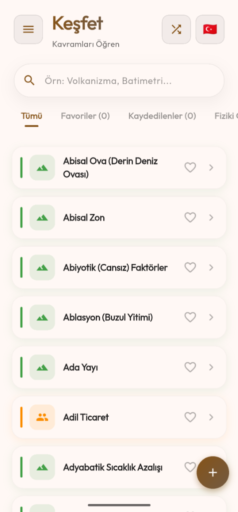
Term Search & Filtering
Research Domains & Methodology.
Core research disciplines and technical methodologies bridging geographical theory, satellite remote sensing, spatial databases, and modern programming.
Remote Sensing & Satellite Analytics
Multitemporal Earth observation across Landsat and Sentinel constellations. Automated spectral indices calculation, hydrological surface tracking, and cloud-native raster pipelines.
GIS & Spatial Data Engineering
Engineering robust spatial databases with PostGIS and GiST spatial indexing. Vector topology validation, geoprocessing algorithms, and enterprise geospatial data modeling.
Geospatial Software & Web Tooling
Automated spatial data processing pipelines with Python, geospatial REST APIs, vector transformations, and modern type-safe interactive web interfaces.
Physical & Human Geography Methodology
Holistic geographical synthesis: Modeling physical terrain dynamics (DEM, geomorphology) alongside human settlement hierarchy, regional demographics, and land use (LULC).
1984–2025 Akgöl Wetland:
40-Year Satellite Change Analysis
Multi-temporal satellite observation of the Konya Closed Basin ecological collapse using Google Earth Engine & ArcGIS Pro; comparing spectral water indices (MNDWI, NDWI, AWEI) with Otsu dynamic thresholding across a 40-year satellite record.
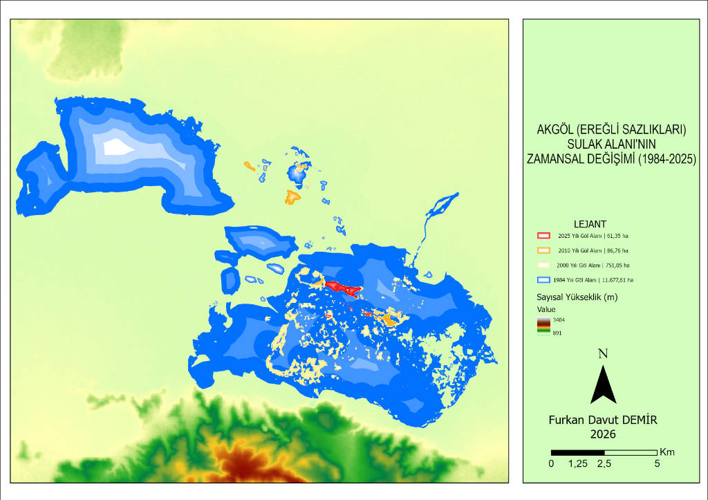
Applied Methodology & Spectral Pipeline
- MNDWI (Xu, 2006) Spectral IndexShortwave Infrared (SWIR) suppresses saturated soil & high reed reflection, isolating true water pixels.
- Otsu Dynamic Thresholding (t=0.175)Automated inter-class variance maximization across image histograms instead of arbitrary static index cutoffs.
- GEE Cloud Computing & ArcGIS Pro CartographyPetabyte-scale multi-decade raster pipeline for cloud-masked summer peak imagery; publication layouts designed in ArcGIS Pro.
The primary driver of the 99.47% loss was the diversion of surface water through upstream dams (İvriz in 1985, Gödet in 1988), followed by massive unmonitored groundwater extraction (thousands of illegal deep wells) causing water table drops of up to 15.9 meters.
#30DayMapChallenge 2026
A 30-day thematic cartography challenge bringing together open satellite imagery, digital elevation models (DEM), and spatial analytics.
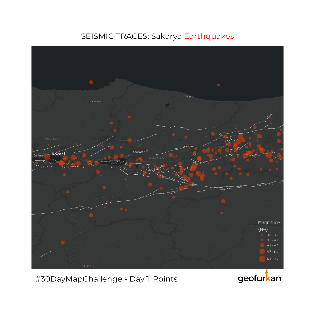
WGS84 · 40.77° N, 30.40° E
Seismic Traces: Sakarya Earthquakes
A discrete spatial breakdown of seismic energy accumulated on the Sakarya segment of the North Anatolian Fault (NAF) from August 17, 1999 to the present.
Seismic energy is emphasized through sized "neon" symbology; fault lines are kept subdued against the dark basemap to maintain visual focus on point earthquake clusters.
Cartographic Narratives & Map Stories.
Transforming biogeographical research, satellite telemetry, and spatial analyses into interactive map narratives with ArcGIS StoryMaps.

“Hope always exists, even if you are a Loggerhead Sea Turtle!”
Furkan Davut DEMİR · Spatial StorytellingLIVING ON HOPE: TUBA
Nesting beaches, biogeographical life cycle, and satellite telemetry tracking of Loggerhead Sea Turtles (Caretta caretta) along Mediterranean and Turkish coasts.
- GIS analysis of İztuzu, Patara, Çıralı, and Akyatan nesting beaches
- Pelagic habitat distribution across the Mediterranean and oceans
- Step-by-step satellite telemetry migration tracking on interactive maps
- Synthesis of marine protected areas and environmental threats
Empirical Fieldwork & Research
Direct on-site observation and measurement of geomorphological and environmental earth systems.
Karst Speleology & Cave Morphology
Empirical field analysis of limestone dissolution galleries, stalactite formation, and structural fracture networks.
Lithological Stratigraphy & Sedimentation
Field observation of sedimentary rock bedding dip/strike attitudes and structural micro-fault planes.
Coastal & Hydrological Basin Dynamics
Temporal lake shoreline shifts, sediment budget calculations, and littoral drainage basin modeling.
GIS Spatial Integration & Synthetic DEM
Transforming ground-truth GPS survey points and structural measurements into calibrated digital elevation models.
Let’s Build Spatial Solutions Together.
For satellite remote sensing research, spatial database architecture, or mobile field mapping solutions, feel free to reach out.