

40-Year Spatial Change in Akgöl Wetland:
The Role of Climatic Factors and Anthropogenic Pressures
Multi-spectral satellite reconstruction (1984–2025) of the ecological collapse of Ereğli Akgöl Reeds in the Konya Closed Basin. Combining Landsat & Sentinel-2 archives on Google Earth Engine with dynamic Otsu thresholding to dissect how upstream dam construction, deep aquifer overdraft, and meteorological drought eliminated 99.47% of the open water surface.
40-Year Water Mirror Contraction Dynamics (1984–2025)
Multi-temporal quantitative time-series derived on Google Earth Engine using 30x30m Landsat surface reflectance and dynamic Otsu thresholding. Hover across years to inspect hydrological shock points and satellite sensor archives.
1984–2025 Multi-Decadal Contraction Dynamics
Ecological Collapse: Lake confined to 6,700m artificial levee impoundment remnant (DSİ)
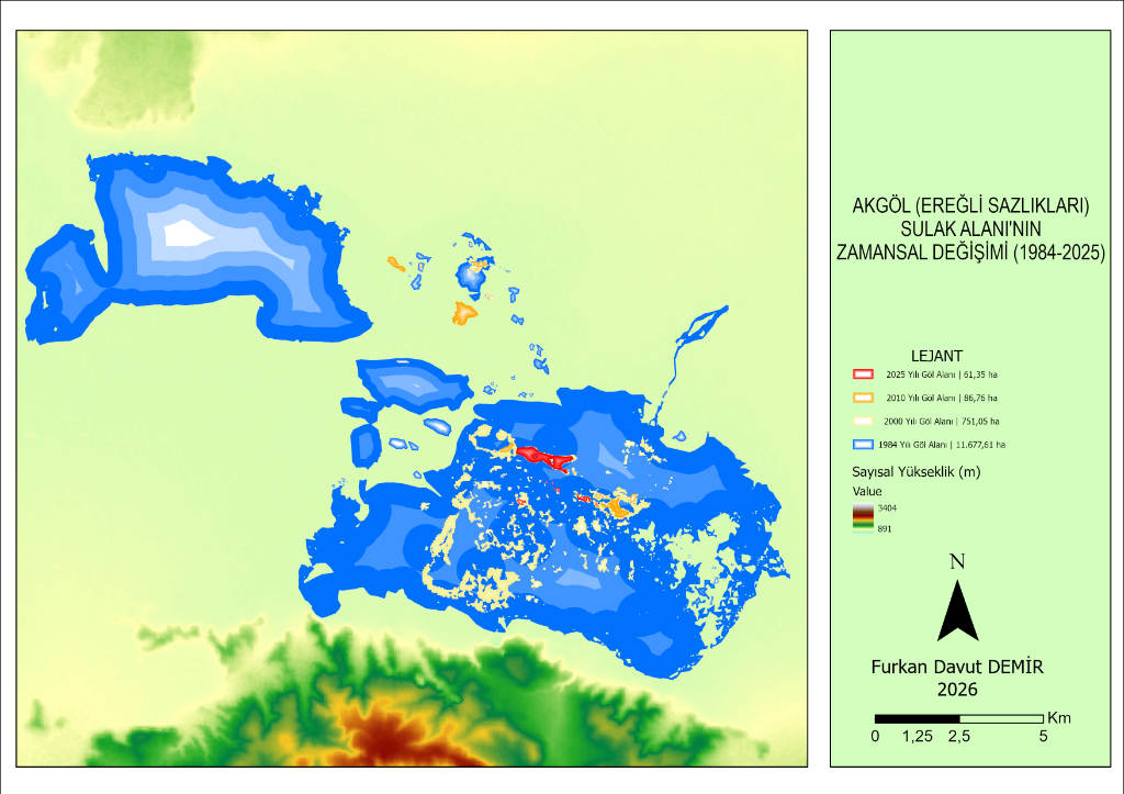
High-Resolution Spatial Documentation
Ramsar-Grade Biodiversity Lost to Anthropogenic Desiccation
Historically commanding an expansive watershed influence of approximately 21,500 hectares, Akgöl Wetland lost almost all of its surface hydrological recharge following the construction of upstream storage dams (İvriz, Ayrancı, and Gödet) and massive agricultural groundwater overdraft, transforming an open water mirror into a dry, salt-crusted depression (Tapur, 1998; Ceyhun et al., 2001; Zeybek & Gür, 2006).
From a biodiversity perspective, the Akgöl Reedbeds harbored an extraordinarily rich flora and fauna, serving as a genetic refuge of global ecological standing (Zeybek & Gür, 2008). Situated directly along one of the two major avian migratory flyways crossing Turkey, the wetland functioned as an indispensable stopover, staging, breeding, and feeding haven for migratory waterfowl (ÇŞDTVKGM, 2014; WWF, 2016).
Designated as a strict natural reserve due to unique landscape geomorphology.
6,800-hectare contiguous core reedbed ecosystem granted absolute protection status.
Ranked #1 among 78 critical avian sanctuaries, meeting full Ramsar criteria.
Critically endemic species restricted to shallow, fresh-to-brackish habitats across the Konya Basin.
Local ichthyological heritage documented exclusively in Akgöl and its connected drainage channels.
Breeds in littoral reed beds and benthic substrates, severely threatened by persistent water retreat.
Quantitative Dynamics: 11,667 ha Down to 61.35 ha
Surface reflectance processing from Landsat 5 TM and Landsat 8 OLI summer archives (July 01 - August 31) using MNDWI and dynamic Otsu thresholding reveals that wetland loss occurred via sudden engineering threshold collapses rather than gradual linear drying:
| Epoch | Water Area (Hectares) | Period Change | Loss vs 1984 | Ecological Status |
|---|---|---|---|---|
| 1984 | 11.667,61 ha | Baseline | -%0 | Expansive open water surface, 21,500 ha watershed impact, contiguous reedbeds. |
| 1990 | 3.322,76 ha | -%71,55 | -%71,55 | Immediate sharp desiccation following the completion of İvriz (1985) & Gödet (1988) dams. |
| 2000 | 751,05 ha | -%77,40 | -%93,57 | Severe reed ecotone fragmentation; open water retreats into shallow disconnected micro-basins. |
| 2010 | 86,76 ha | -%88,45 | -%99,26 | Historic minimum dry bed coinciding with intense regional drought and unmonitored deep wells. |
| 2020 | 246,77 ha | +%184,43 | -%97,89 | Transient anomaly driven by wet spring rains and irrigation drainage channel discharges. |
| 2025 | 61,35 ha | -%75,14 | -%99,47 | Complete ecological collapse. Lake confined to a 6,700 m artificial levee impoundment (DSİ). |
The Lethal Combination: Upstream Dams & Groundwater Overdraft
Akgöl was a terminal closed-basin wetland with no natural outlet, replenished exclusively by runoff descending from the Bolkar Mountains. Construction of the İvriz Dam (1985) and Gödet Dam (1988) impounded hundreds of millions of cubic meters of water for intensive irrigation, severing the lake’s primary lifelines. The catastrophic 71.55% surface collapse between 1984 and 1990 was the direct outcome of these civil engineering interventions.
Once surface streams were impounded, regional agriculture pivoted toward water-intensive monocultures (maize and sugar beet), causing an explosion in groundwater exploitation. Across tens of thousands of registered and illegal deep wells, the regional static water table plummeted by an average of 15.9 meters (56.8 cm/year). Deprived of upward baseflow recharge, the desiccated lake floor collapsed, accelerating regional sinkhole formation.
Major Upstream Hydraulic Barriers in the Basin
Retained the primary surface recharge of Akgöl for agricultural irrigation, triggering an immediate 71.55% surface collapse within 5 years.
Sealed western sub-basin runoff and prevented flash-flood recharge from reaching the southern marshlands.
Early hydrological barrier that retained seasonal runoff from the Karaman-Ayrancı southern slopes.
Why MNDWI Instead of Conventional NDWI in Shallow Marshes?
Employing a single spectral index in complex wetland ecotones introduces severe misclassification errors. In shallow basins such as Akgöl with dense reed canopy (Phragmites australis) and summer salt-crusted mud, the McFeeters (1996) NDWI misclassifies saturated soil as open water while mislabeling emergent reeds as dry land. Xu’s (2006) MNDWI replaces NIR with the SWIR1 band, which exhibits near-total water absorption, cleanly suppressing vegetation and soil reflectance to achieve superior delineation.
Water pixels exhibit maximum absorption in SWIR wavelengths, effectively suppressing reed shadows and dry soil noise.
Automated inter-class variance maximization across image histograms instead of arbitrary static index cutoffs (optimum 0.175 for 1985).
Multi-band weighted formulation optimized to suppress dark mountain shadow surfaces and built-up urban noise.
Normalized Difference Moisture Index used as a cross-verification layer to distinguish saturated mudflats from true open water bodies.
4 Steps to Prevent Irreversible Desertification
Establish a cloud-based automated early warning framework on Google Earth Engine that calculates wetland water surface and moisture budget over each 15-day Sentinel-2 revisit cycle.
Enforce minimum environmental flow releases from İvriz Dam, routed via Digital Elevation Model (DEM) micro-topography into optimum shaded depressions to minimize evaporative losses.
Deploy Random Forest parcel-level crop classification to detect illegal water-thirsty monocultures (corn, sugar beet), enforcing the closure of unpermitted deep extraction wells.
Plant indigenous halophytic and xerophytic vegetative shelterbelts across the 11,000-hectare dried lake bed to prevent severe regional saline dust storms and wind erosion.
Have Questions, Observations or Feedback?
Feel free to get in touch if you have observations on this study, inquiries about the spatial methodology, or questions about the research findings.